Inspiration ASP Proposal
The Town of Pincher Creek will be holding a Public Hearing on August 25, 2025 in Town Council Chambers at 962 St. John Avenue regarding proposed bylaw 1638-25 - Inspiration ASP.
How to Submit Comments
If you would like to submit comments or require further information on this proposed bylaw please email
reception@pinchercreek.ca or call 403-627-3156, during normal business hours.
Please forward written submissions on or before August 20, 2025, at 4:00 PM.
How to Attend the Public Hearing
A public hearing to consider the proposed Bylaw will be held in person in Council Chambers at the Town office 6:00 p.m. on August 25, 2025.
If you would like to speak at the public hearing or listen in, please contact the Town at
reception@pinchercreek.ca by 4:00 p.m. on August 25, 2025.
-
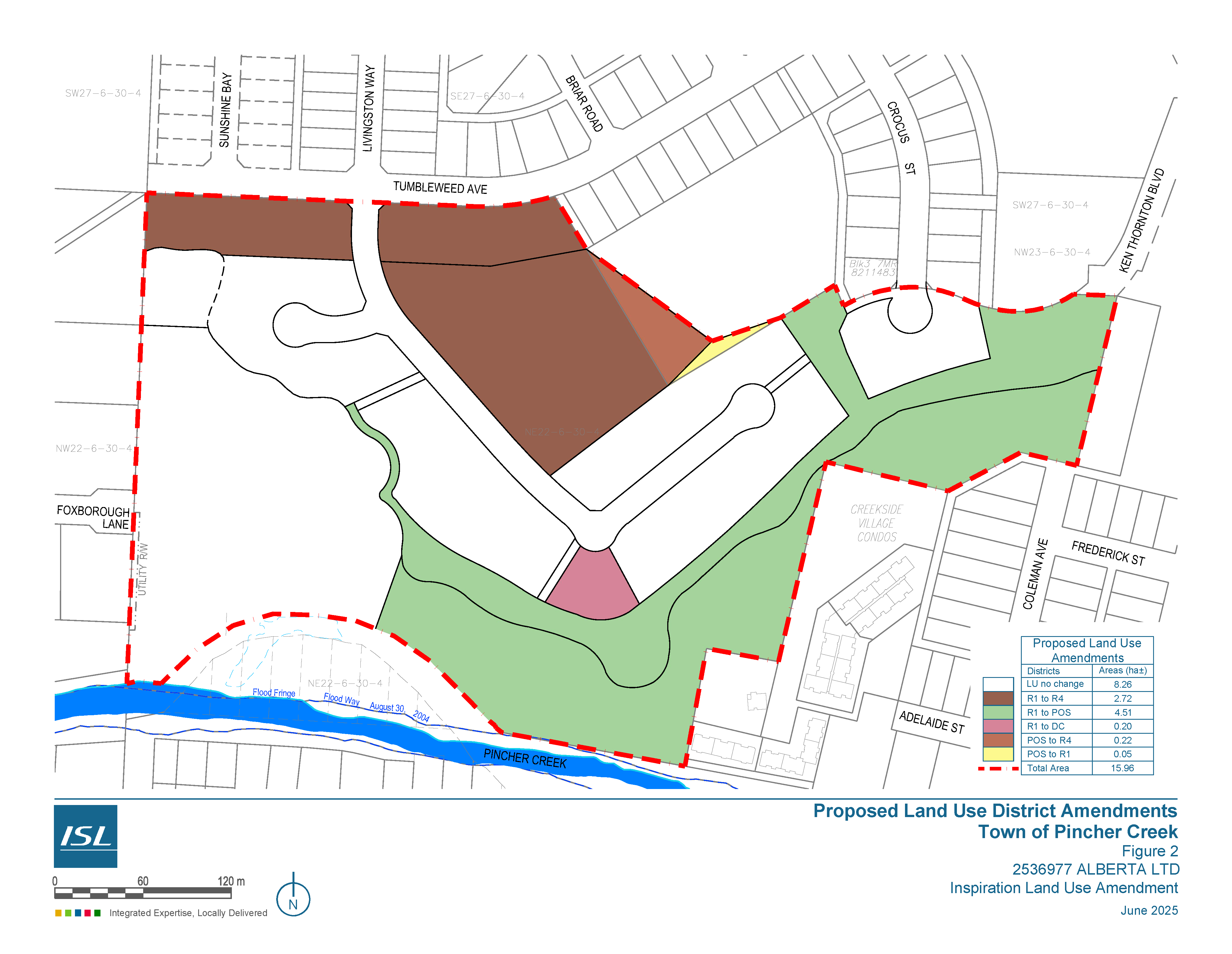
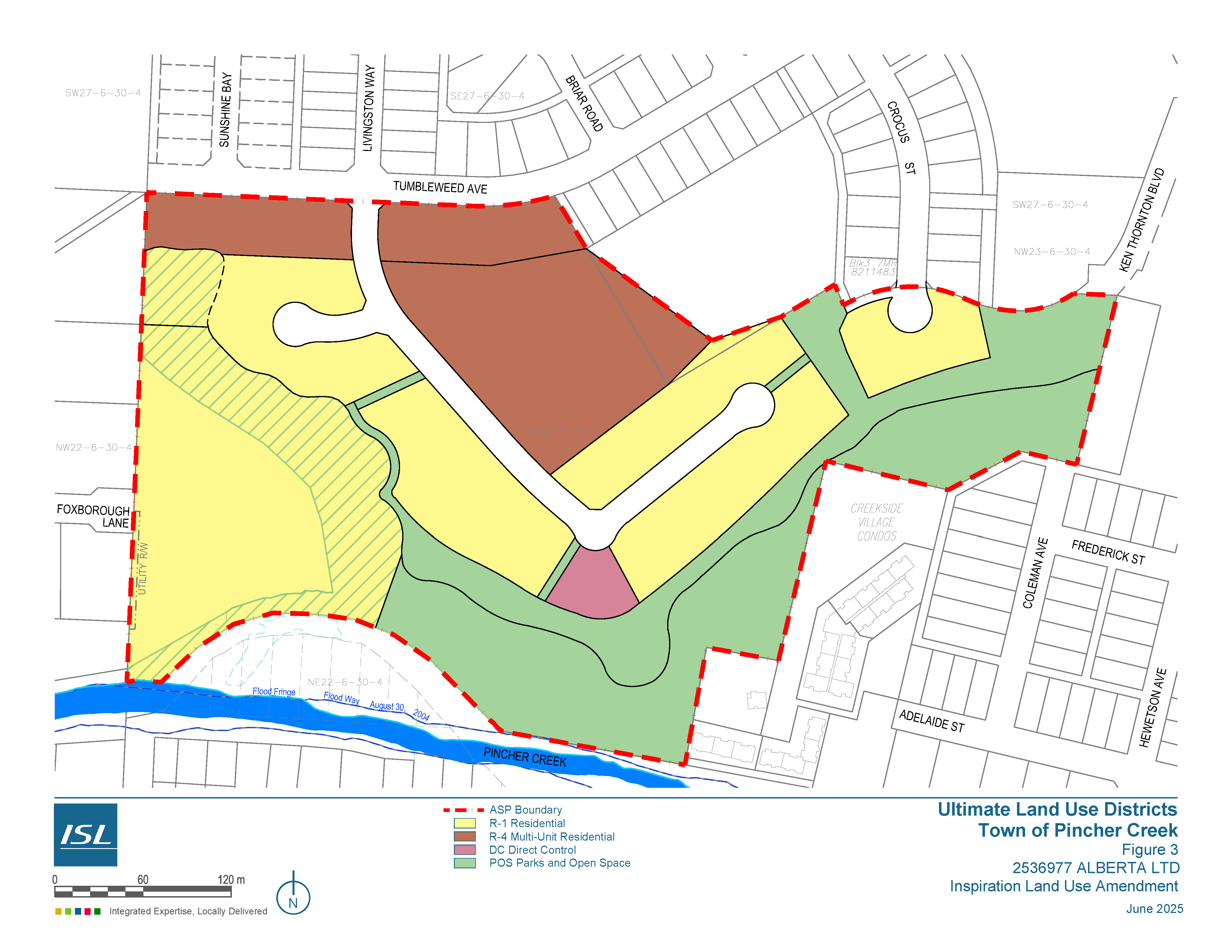
Single Detached Residential. The plan accommodates primarily single detached residential uses and is already designated R-1, Residential District. A small portion of the existing POS site has been incorporated into the development area to accommodate lot sizing.
-
Approximately 0.05 hectares are anticipated to be redesignated from POS, Parks and Open Space District to R1, Residential District.
-
Multi-Unit Residential. A 1.88 hectare parcel in the centre of the plan is intended to provide opportunities for a multi-unit residential development at a proposed density of 75 units per hectare. The parcel is intended to accommodate up to 141 units, which may provide an opportunity for seniors housing.
-
Approximately 34 multi-unit dwellings in the form of townhouses have been proposed along the Tumblewood Avenue to provide an alternate housing choice.
-
Approximately 2.72 hectares are anticipated to be redesignated from R1, Residential District to R4, Multi-Unit Residential District.
-
Approximately 0.22 hectares are anticipated to be redesignated from POS, Parks and Open Space District to R-4 Multi-Unit Residential District.
-
Direct Control. A Direct Control parcel is proposed along the escarpment on the upper portion of the development area. The parcel is currently designated R-1 Residential and is proposed to follow the rules of the R-1 district with the addition of Personal Service Uses as a discretionary use to accommodate the operation of spa services at a local level within the neighbourhood.
-
INTENT: The intent of the Direct Control land use district is to accommodate a spa within the neighbourhood.
-
PERMITTED/DISCRETIONARY USES: The permitted and discretionary uses shall be the same as the R-1 Residential District with the addition of the following use as a discretionary use:
-
Personal Service Use
-
REGULATIONS: The regulations of the R-1 Residential District shall apply, including:
Minimum Lot Size
-
Minimum Setback Requirements
-
Maximum Lot Coverage
-
Maximum Building Height
-
Standards of Development
-
Home Occupations
-
Moved-In Buildings
-
Parking Space Requirements
-
Landscaping and Screening,
-
Bed and Breakfast Operations, and
-
Signs
Approximately 0.20 hectares are anticipated to be redesignated from R1, Residential District to Direct Control
-
Recreation/Open Space. The open space throughout the plan area, has been designed to accommodate connections to the natural area within convenient walking distances for all residents. This open space network provides meeting areas and aesthetic focal points and enhances overall walkability by providing valuable connections within and beyond the ASP area. Where possible, portions of the environmentally sensitive areas have been incorporated into the rear yards of development parcels as environmental easements. On the east side of the plan, incorporating easements into private parcels would preclude the opportunity to provide a trail along the top of bank, and in these areas, the environmentally sensitive areas are proposed to be dedicated as Environmental Reserve (ER). Setbacks from the slope stability line, ranging from 6m to over 15 m were established in the Geotechnical Evaluation and areas between the top of bank and the slope stability line are proposed to be dedicated as either rear lots of residential parcels or Municipal Reserve (MR).
A small portion of the existing MR parcel within the Plan area has been reconfigured within the overall design of the ASP area. The majority of the existing MR parcel will remain POS, Park and Open Space District.
Approximately 4.51 hectares are anticipated to be redesignated from R1, Residential District to POS, Park and Open Space District to fulfill the reserve obligation for the developable land, compensate for the disposal of reserve lands from the existing POS parcel and dedicate lands as Environmental Reserve.
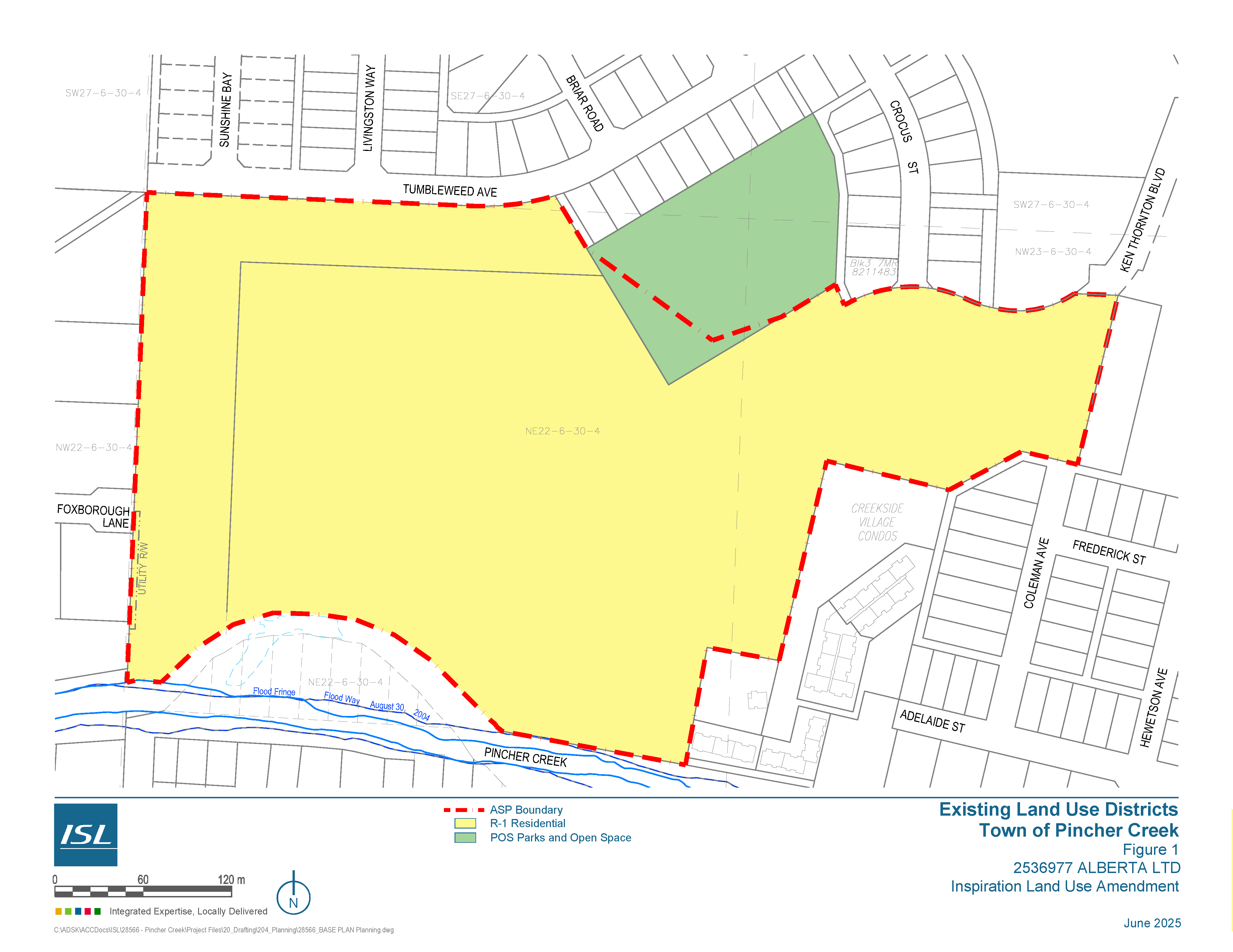
The following figures outline the existing and proposed districts:
-
Figure 1: Existing Land Use Districts
-
Figure 2: Proposed Land Use District Amendments
-
Figure 3: Ultimate Land Use Districts
Downloadable PDF - click here
According to Section 9 of the Municipal Government Act (MGA), lands dedicated as municipal reserve may only be used by a municipality or school board for specific purpose purposes such as public park, school board or community purposes, non-profit facilities and affordable housing.
The ASP area includes three separate areas. Two of the parcels, Title No. 141 281 928+1, and Title No. 141 281 928 are privately owned and will be required to provide 10% Municipal Reserve based on the area of the parcels, less the Environmental Reserve and Environmental Easements.
The third parcel, a 1.76 ha rectangular parcel is currently designated as municipal reserve. A small portion of the MR parcel has been reconfigured within the overall design of the ASP to accommodate minimum lot depths and parcel configuration.
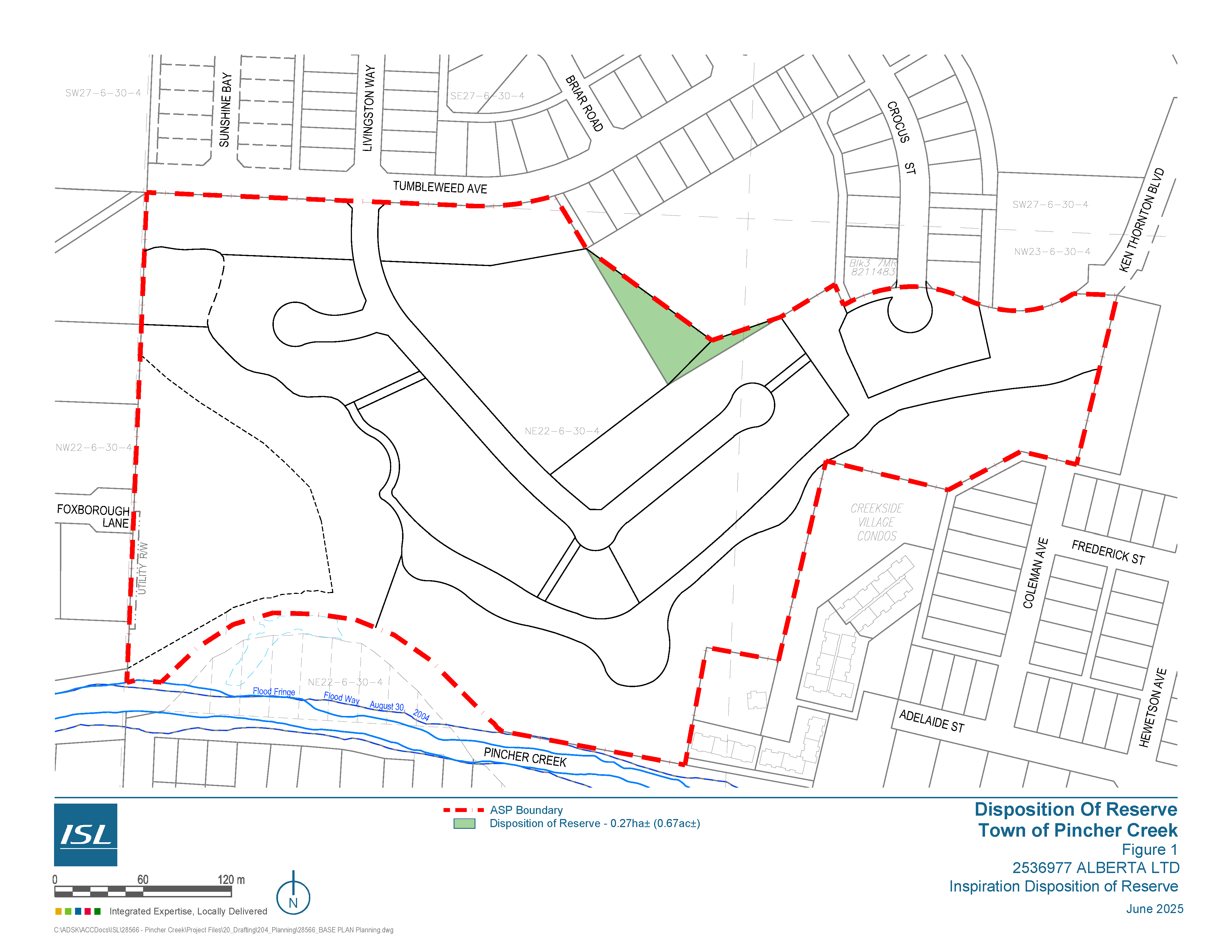
A formal Disposition of Reserve will be required to redesignate 0.27 of the existing POS site to R1 and R4 to accommodate the proposed residential development. These lands are highlighted on Figure 1: Disposition of Reserve. A calculation of MR owing is provided in the tables below.
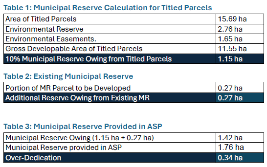
While there is no loss of municipal reserve to the community, prior to disposal of dedicated reserve a public hearing must be held, concurrent with the Land Use Redesignation amendments for the subject lands.